
Loushankuan Fm
Type Locality and Naming
The type locality of the Loushankuan Formation located between Tongzi County in the north and Huichuan District of Zunyi City in the south. No type section was assigned when Liu (1942) proposed the unit. An auxiliary section, the Yankong section, was proposed by Yin in Dong (1997) as representative section of the formation. The middle and lower parts of the section are served also as the auxiliary section for the underlying Chintingshan Fm, Mingsinssu and Niutitang formations. The section lies near Yankong Town in Yankong Township, about 11 km northeast of the seat of Jinsha County, Bijie City, western Guizhou Province (106°13’E, 27°37’N), and was measured by Zhang Zhenghua, Zhou Zhiyi, and others from the Institute of Geology, Guizhou Headquarter of Petroleum Exploration and the Nanjing Institute of Geology and Palaeontology, Chinese Academy of Sciences in 1970. In this section, the Loushankuan Formation is 1048.0 m thick. The formation was first published by Liu (1942). The name is derived from Loushankuan (spelled Loushanguan in Hanyu Pinyin) Pass in the middle section of the Daloushan Mountain, which is located in Tongzi County, Zunyi City, north-central Guizhou Province. Originally the formation was called Loushankuan Limestone by Liu (1942) and was subsequently remand Loushankuan Group by Lu (1962) and Loushankuan Formation by Zhang et al. (1964). The name was first appeared in a 1930 manuscript by Ding Wenjian, which was edited and published subsequently by Huang (1947).
Synonym: (娄山关组)
Lithology and Thickness
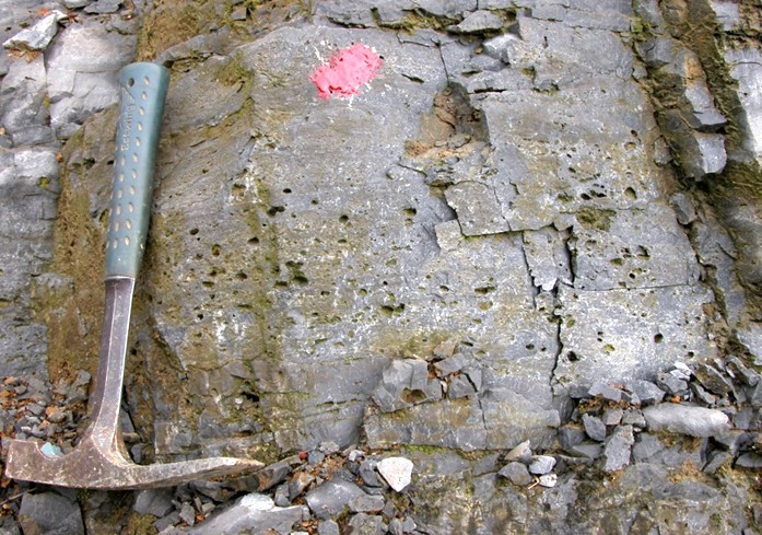
The Loushankuan Formation is a carbonate (dolomite dominated) sequence. The formation can be roughly divided into three parts: Lower part usually is dominated by thin-bedded dolomite. Middle part is medium-bedded dolomite with numerous interbeds of brecciated dolomite; Upper part consists of thick-bedded dolomite bearing chert-lumps partially. The formation contains gypsums, halite pseudo-crystals and stromatolites.
[Figure: Dolomite containing halite pseudo-crystals from the upper part of Loushankuan Formation in the Yankong section, Jinsha County, northern Guizhou Province.]
Relationships and Distribution
Lower contact
The Loushankuan Fm rests conformably on the underlying Douposi Fm in northeastern Yunnan, on the Kaotai Fm, Shilengshui Fm, Pingjing Fm, and Jialao Fm in Guizhou Province, and on the Huaqiao Fm in northwestern Hunan Province.
Upper contact
It is conformably overlain by the Maotain Fm in northeastern Guizhou Province and by the Nanjinguan Fm in eastern Chongqing Municipality and southwestern Hubei Province. In other localities, it is in disconformable contact with overlying formations of different ages, i.e., Middle Ordovician, Upper Carboniferous, or Permian System.
Regional extent
The Loushankuan Formation is widely exposed over the Yangtze, the Jiangnan Slope and the Jiangbei areas of South China Region, distributed in eastern Sichuan Province, northern Guizhou Province, western and northwestern Hunan Province, southwestern Hubei Province, and southern Shaanxi Province, and Chongqing Municipality. In the eastern part of northern Guizhou, i.e. east of the line of Pingtang‒Weng’an‒Fenggang counties, a vertical line just equally divided Guizhou Province, the formation increases calcareous content, and even eastward to the border area between Guizhou and Hunan provinces, the formation increases several interbeds of limestone. The formation is usually 1000 m thick, and has a tendency of decreasing thickness southwestward. In Hunan, in area of Longshan County, the most northwestern part of the province, the formation is 1500‒1700 m thick, and it rapidly becomes thinned southeastward to 103‒320 m in Yongshun, Huayuan, Boajing and Fenghuang counties, northwestern Hunan. In southern Shaanxi, it is merely 110-150 m thick.
GeoJSON
Fossils
The Loushankuan Formation is very poorly fossiliferous. However, in northwestern Hunan (Longshan County), the formation yields Blackwelderia sp., and Calvinella walcotti, indicating a late Guzhangian through Furongian age. Some late Furongian conodonts, Teridontus nakamurai and Cordylodus proavus, were also reported from the formation
Age
Depositional setting
Additional Information